
Abstract
Content
- 1. Actuality of work
- 2. Goal and tasks of the research
- 3. Creation systems of town planning cadastre in Ukraine
- 4. Oversea creation systems of town planning cadastre
- 5. Possible results which are expected at implementation of work
- References
1. Actuality of work
Development of town planning cadastre of regional and local level in Ukraine is an important state task.
On this time there is not the unique town planning cadastre in Ukraine, there are only separate subsystems: CAS of conduct of duty plan of city and subsystem of conduct of electronic archive of town planning document, created the Kharkov communal enterprise the City information center
consonant with a company Sigma-meson of LTD
. Methodology and structure of conduct of town planning cadastre AR Crimea by the state enterprise of Dypromysto
of the name of Yu.M.Belokon.
In master's degree work the tasks of determination of parameters and structure of the informative system of town planning cadastre of local level, tech charts development and information processing in the system of town planning cadastre and creation of model of database town planning document, are examined on the example of city Krusnyi Liman.
2. Goal and tasks of the research
Purpose of work: Development tech charts development and information processing of local level.
Main tasks of the research:
- Analysis of conduct of town planning cadastre in Ukraine and by a foreign country.
- Determination of parameters and structure of the informative system of town planning cadastre of local level, development tech charts development and information processing in the system of town planning cadastre.
- Creation of model of database town planning document.
3. Creation systems of town planning cadastre in Ukraine
A ponderable conduct of the system is on a few levels (pic. 1), for each which the aggregate of information, intended for functioning of the system is foreseen of [1].
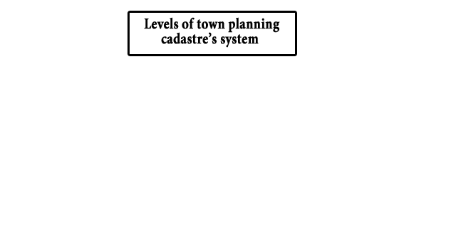
Picture 1 – Even systems of town planning cadastre of Ukraine
(animation: 41 shot, endless amount of cycles of reiteration, 92.5 KB)
In accordance with the order of the daily meeting of Kiev city advice from September, 20, 2012 Main administrations of town-planning and architecture were brought in by offering to Kiev city advice to confirm the city having a special purpose program of creation and introduction of the Town planning cadastre of Kiev on 2013-2015.
In obedience to the project of decision of this question the program realizations of it are foreseen in two stages. On the first stage, which, as foreseen, will last during 2013-2014, consists in development of technical base, leadthroughs of taking of inventory of information, for bringing in a cadastre, to development of informative model of cadastre, start of the system of the inquiry processing. During the second stage, carried out during 2015, introduction of town planning bank of data, introductions of resources of town-planning cadastre, providing of organs of power and local self-government town-planning information, will be carried out.Financing of this project is foreseen due to a city budget (in obedience to the requirements of decision of Cabinet Ukraine № 559 from May, 25 2011). This suggestion was accepted. Service of town-planning cadastre will carry out operations from a receipt and registration of cadastre information, on the roughing-out of information, bringing of information, in the base of cadastre, on forming and delivery of cadastre documents, on previous consideration transmission proprietors, users and managers of lot lands, buildings and buildings, in relation to the foreseen changes or reconstruction on accordance operating town-planning norms.
This decision is continuation on a way to to implementation of requirements of decision of Cabinet Ukraine № 559 from May, 25, 2011 next to a decision–making about creation of Service of town planning cadastre of city of Kiev, ratified on meeting of Kievan city advice on the session of May, 25 in 2012. The basic tasks of service is the informative providing of subjects of town planning activity, grant of documents, for confirmation of the state and quality of objects for market of the real estate development, conducts of the town-planning monitoring, and organization of priv town planning cadastre from natural, technogenic and criminal threats [2,3].
In the Autonomous republic Crimea to the end of 2011 by the Ukrainian state research institute of planning of cities Dypromisto
to the name of Y.N.Belokon realizable development of the first stage of Measures on development of town-planning cadastre ARE Crimea
. The first stage includes for itself creation of methodology and structure of conduct of town-planning cadastre. At development of this document aims and tasks of town-planning cadastre of Autonomous Republic Crimea were selected, structural komponenty of the system is certain with distributing of duties on the proper organs, a volume and order of information, necessary for realization of the put aims transfer is certain, composition and even systems of town-planning cadastre is certain ARE Crimea, order of creation, functionings of the system, proprietors, users and users of cadastre information, are indicated; the territorial and informative structure of the system is resulted on district and local levels.
Presently, within the framework of pilot project, by the Republican committee of ARK on building and architecture jointly with service of town-planning cadastre of city advice of Feodosia work on creation of town planning cadastre of city and settlements is conducted, inferiors to Feodosia city advice.
Now the specialists of service of town planning cadastre are execute a study and analysis of existing planned cartographic materials, earth-registration document, materials of taking of areas within the limits of city, town planning document, materials of taking of inventory of objects of past years and materials of executive survey [4].
In the Kharkov Communal enterprise the City information center
jointly with a company Sigma–meson of LTD
during a few years conducted work on creation of informative CAS of town planning cadastre and monitoring (AIS GKM). As basis for the construction of AIS GKM ARCGIS software was used 9.3 companies of ESRI.
To date the system successfully functions in subsections of Department of town planning, architecture and landed relations of the Kharkov city sonnet, thus such subsystems are most full realized to date: CAS of conduct of duty plan of city and subsystem of conduct of electronic archive of town-planning document [5].
CAS of conduct of duty plan is intended for the operative monitoring of changes on territory of city, works related to the leadthrough on building and reconstruction of objects of city environment. The system allows to fix the results of geodesic pretentious novelties on the electronic map of city. Materials of geodesic surveys which enter department of town planning cadastre and have a different form (paper, digital) and different quality, compared with the concrete area of territory of city and checked for accordance operating norms.
This system also plugs in itself information about the given permissions on project works, about the given out tts, about the got concordances, information about project organizations, date of development and claim of project, and also information about the predictable placing, building terms and basic technical descriptions of object.
On the basis of this information permission on the leadthrough of geodesic pretentious novelties is given out. Composition of information which permission is formed on the basis of includes information about the customer of project, place of location of object and his basic descriptions, and also registration number of project. The previous scopes of the designed object are fixed in a register and on the proper informative layer of plan of city.
4. Oversea creation systems of town planning cadastre
In Russian Federation developed and inculcated in exploitation the Informative system of providing of town planning activity (ISPTA) is the systematized vault of the documented information about development of territories, their building, lot lands, objects of capital building and other necessary for realization of town planning activity of information. The informative systems of providing of town planning activity plug in itself materials in a text form and as maps (charts) [6].
Native differences for creation of municipal ISPTA led to forming of the different going near determination of the basic setting of the systems.
It is possible to select the followings basic going near determination of setting of ISPTA:
- The municipal geographic information system is the informative system, which provides collection, storage, treatment, access, reflection and distribution of prostranstvenno-koordinirovannykh of information (spatial information) on territory of municipal education. Municipal GIS device information of the remote sensing, special information which behave to the objects of territory, integrate cartographic information, for example is information about engineerings networks; statistical information on territory, information of the ecological monitoring and other information which behaves to the objects on territory.
- Depository of the archived documents.
- System of workflow, related to town planning activity. For comfort of the use of automated ISPTA, and additional stimulus, for employees, those documents which prepare in the organs of architecture and town planning are formed the system it is automated, both phototypograph and graphic part.
- System of collection and grant information.
- Instrument of planning of development of territory of municipal education. Informative CAS allows to form queries on territory, to determine the possible use of territory, parameters of objects, predictable to placing on territory. Only at presence of valuable access to information about territories potential investors will be able to estimate its investment attractiveness and accept the grounded decisions in relation to development of territory.
- System of monitoring of the use of territory. The monitoring system allows to watch the functional use of territory and objects on territory, to watch the state of objects of town planning activity.
System of the town planning Los-Anzheles plugs in itself a structure, represented on a pic. 2 [7].
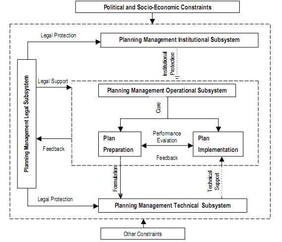
Picture 2 – Schematic structure of the system of management of the town planning
5. Possible results which are expected at implementation of work
Analysing the above–mentioned examples of attempts of creation of town planning cadastre in Ukraine and by a foreign country, the decision of the followings tasks is expected:
- Determination of parameters and structure of the informative system of town planning cadastre of local level.
- Tech charts development and treatment of information is in the system of town planning cadastre.
- Creation of model of database town planning document.
It is planned to create CAS of town planning cadastre in the software product of ArcGIS 10.1.
References
- Золотова Е.В. Основы кадастра: Территориальные информационные системы: Учебник для вузов.– М.: Академический Проект; Фонд "Мир", 2012. – 416 с. – (Gaudeamus: Библиотека геодезиста и картографа).
- Постанова Кабінету Міністрів України від 25 травня 2011 р. № 559 "Про містобудівний кадастр".
- Сайт Мир Квартир. "Главархитектуры предлагает утвердить градостроительный кадастр Киева на 2013–2015" [Электронный ресурс]. – Режим доступа: http://mirkvartir.ua/news....
- Сайт Мир Квартир. "В Феодосии разрабатывают градостроительный кадастр города" [Электронный ресурс]. – Режим доступа: http://mirkvartir.ua/news....
- Сайт Геоинформационные системы для бизнеса и общества. "Опыт построения автоматизированной информационной системы градостроительного кадастра и мониторинга" [Электронный ресурс]. – Режим доступа: http://www.dataplus.ru/news/arcreview....
- Сайт Управление градостроительной информации [Электронный ресурс]. – Режим доступа: http://www.gisort.ru/.
- Xueming Chen. Urban Planning Managment System in Los Angeles: an Overview // Theoretical and Empirical Researches in Urban Management. – 2009. – №2(11). – С.50–63.