
Abstract
Content
- Introduction
- 1. Relevance of the topic
- 2. The purpose and objectives of the study
- 3. Review of literary sources
- 3.1 World practice of applying comprehensive assessment
- 3.2 Development of a comprehensive assessment of the state of geosystems in the Russian Federation (Rostov region)
- 4. Analysis of the study on integrated assessment in the Donetsk region
- Conclusion
- References
Introduction
Urbanized territories are distinguished by a number of specific features of functioning and environmental pollution [1].
High population density, concentration of industrial enterprises and transport, intense impact of environmental, economic, social factors on the state of geosystems have a significant impact on the environment. A special place in carrying out a comprehensive environmental assessment is given to the choice of methods and indicators that reflect their features [1].
The study of the ecology of cities and the assessment of the state of urbanized territories in recent years is a highly demanded interdisciplinary area of ??scientific thought, the analysis of which is the subject of the works of many foreign researchers, including Mark McDonnell, Richard Foreman, Nancy McIntyre, Jar Nimela, Steward Picket, and others.
As a result of research on the topic of the master's thesis, the goal will be achieved – the development and substantiation of a comprehensive assessment of the state of geosystems in a certain territory, for making effective management decisions based on environmental reporting of enterprises, reports of regional and federal authorities on the state of the environment and the use of natural resources.
1. Relevance of the topic
Methodology for assessing any territory that allows you to make some decisions. Identification of hazardous influences on the environment and ways to solve them. Development and substantiation of a comprehensive assessment of the state of geosystems in a certain territory, for making effective management decisions based on environmental reporting of enterprises, reports of regional and federal authorities on the state of the environment and the use of natural resources.
Improvement of the methodological basis for a comprehensive assessment of the state of ecosystems of urbanized territories of the Donetsk region for optimization, planning and implementation of environmental protection activities, and their balanced development.
2. The purpose and objectives of the study
The aim of the study is to improve the methodological basis for a comprehensive assessment of the state of ecosystems in urbanized areas of the Donetsk region for the optimization, planning and implementation of environmental protection measures and their balanced development.
To achieve this goal, it is necessary to solve the following tasks:
- Conduct an analysis of research, determination of the nature of the parameters of environmental impact during the functioning of geosystems.
- Identify current and potential sources of environmental hazards in a certain area based on an analysis of the environmental situation.
- To carry out a comprehensive assessment of the degree of environmental impact of sources of environmental hazard in the Donetsk region.
- To assess the ecological – economic and social results of the application of a comprehensive assessment of the state of the ecosystem of the region.
3. Review of literary sources
3.1 World practice of applying comprehensive assessment
Today, a comprehensive assessment of geosystems is carried out on the basis of a variety of indices, which differ both in the methods of their determination and in the methodological principles of their construction. There are hundreds of fairly well–known indices and measures in the field of socio–economic development of countries and regions, in the field of environmental protection, ecology and biodiversity. The hypotheses that underlie the models are usually private and subjective and cannot serve as a basis for reliable quantitative methods of assessment, if only because biological, ecological and social systems cannot be assessed by a single, albeit complex, indicator [1].
Today, a comprehensive assessment of natural anthropogenic systems is carried out on the basis of a variety of indices, which differ both in the methods of their determination and in the methodological principles of their construction. There are hundreds of fairly well–known indices and measures in the field of socio–economic development of countries and regions, in the field of environmental protection, ecology and biodiversity. The hypotheses that underlie the models are usually private and subjective and cannot serve as a basis for reliable quantitative methods of assessment, if only because biological, ecological and social systems cannot be assessed by one, albeit complex, indicator. To build quantitative models, it is necessary to develop scales for measuring system state indicators, which would not be subjective in their essence. There are no such quantitative assessment systems in biology and ecology so far [3].
3.2 Development of a comprehensive assessment of the state of geosystems in the Russian Federation (Rostov region)
The current level of the urban population (74%) puts it on a par with most of the developed countries of the world. Urbanization processes have a number of features.
Cities – millionaires, in which 32.4% of the country's population live, are located at a considerable distance from each other, which significantly complicates the development of agglomeration processes and makes it extremely difficult to form megalopolises [4].
Due to the lack of open data, the assessment of the impact of physical factors on the state of urban districts of the region was carried out taking into account the radiation and noise effects. The total anthropogenic load of urban districts is determined by summing up individual types of loads.
The assessment of pollution of individual components of the environment was carried out according to the above, as the main sections of the integrated environmental assessment (Fig.1) of urban districts were taken:
Picture 1 — The main sections of the integrated environmental assessment of urban districts
(animation: 8 frames, 5 cycles of repetition, 134 kilobytes)
The main principles of integrated environmental assessment of urban districts are as follows:
- use of already available data produced in environmental monitoring systems and state statistical bodies;
- application of already available methods for assessing the state and pollution of individual components of the environment;
- simplicity of data processing and the minimum required number of indicators;
- the application of a score when comparing and using indicators with different units of measurement.
In urbanized areas, natural landscapes have been greatly transformed by man, in their place were formed urban districts, suburban agricultural areas, recreational areas.
For the subsequent comprehensive environmental assessment, it is important to characterize environmentally significant factors in the development of urbanized territories, including demographic, industrial and transport potential, social aspects of the development of urban districts. Such information is the basis for determining the characteristics and trends of development of urban districts and establishing anthropogenic pressure.
Resistance of urban districts to anthropogenic impact is determined in general for the total anthropogenic load.
The algorithm for conducting (preparing) a comprehensive environmental assessment of urban districts is shown in Fig.2.
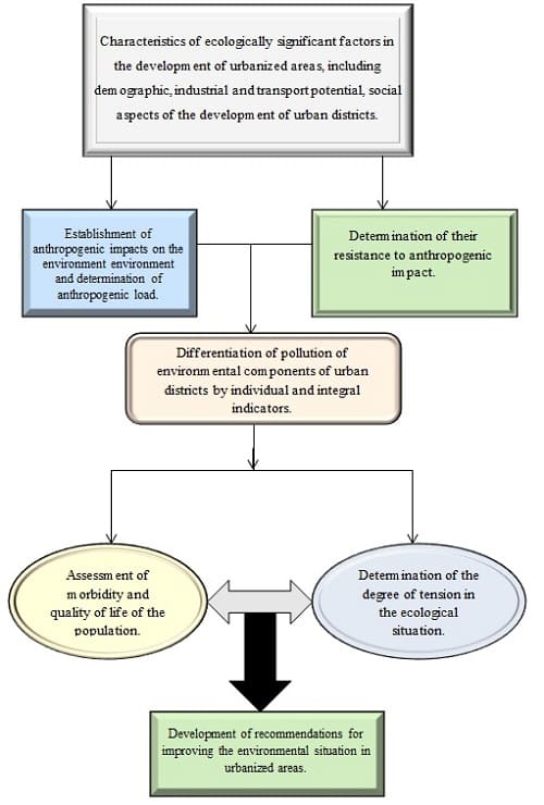
Picture 2 — Algorithm for conducting (preparing) a comprehensive environmental assessment of urban districts
To determine the overall sustainability, it is better to use the ecosystem sustainability index, calculated as the ratio of the radiant energy used by plants to the total mass of energy absorbed in this area.
Establishment of anthropogenic impacts was carried out according to the main direct indicators of the impact of human activities on the environment. These indicators include the number and density of the population, emissions, discharges of pollutants, waste generation, the amount and emissions of vehicles, physical factors of influence, etc.
4. Analysis of the study on integrated assessment in the Donetsk region
1. Air pollution in cities is the most pressing hygienic and socio–economic problem of the present time. The most dangerous technogenic source of air pollution in large industrial cities is motor vehicles. The atmospheric air of Donbass cities is polluted by more than 20 technogenic xenobiotics of varying degrees of danger, eight of which are specific for this industrialized region 6 and are constantly in the air basin in concentrations that exceed hygienic standards [3].
2. The least qualitative water in terms of chemical composition, especially in terms of its pollution with heavy metals, is consumed by residents of the cities of Mariupol, Druzhkovka, Dobropolye, Kramatorsk, Krasnoarmeysk, Konstantinovka and Shakhtersk; they use excessively mineralized, hard water with a significant amount of sulfates and chlorides for drinking, which contains iron, calcium, manganese, lead, copper, nickel, chromium, beryllium, zirconium and barium in concentrations at or above the hygienic regulations.
3. The soil of industrial and urban agglomerations of Donbass is contaminated with lead, magnesium, chromium, zinc, nickel, tin, molybdenum, beryllium, bismuth, titanium, lithium and manganese in concentrations that exceed the established standards from 1.4 to 14.2 times. The total technogenic soil pollution is the largest in the cities of Gorlovka, Yenakiyevo and Konstantinovka (Zn>128) and is classified as extremely dangerous for the health of the population.
4. The least quality food products produced from local raw materials and consumed by the population of Donbass, hazardous to health as a result of excessive pollution with heavy metals, pesticides and nitrates, are consumed by residents of the cities of Makeevka, Yenakiyevo and Gorlovka.
5. A feature of the formation of an eco–crisis region in the pathology of the urban population is the dominance in its structure of diseases of those organs and systems that most intensively come into contact with the external environment: endocrine, nervous, musculoskeletal, genitourinary and cardiovascular systems, respiratory and digestive systems, as well as neoplasms. The proportion of these diseases is 68.9% in the structure of the incidence of diseases, 76.8% in the structure of their prevalence and 83.7% in the structure of mortality in Donbass cities [4].
6. The demographic situation in the cities of the eco–crisis region is unfavorable and is characterized by the transition of the age structure of the population to the regressive type (children – 18.4% less than the elderly – 31.3%), which negatively affects the process of population reconstruction and the state of labor resources, creates an additional basis for further deterioration of public health, including a rapid increase in the incidence of diseases, their chronicity and mortality from them in the population.
7. The modern patterns of the dynamics of the main demographic indicators in the cities of Donbass are a continuous decrease in the birth rate from 1985 to 2005, a rapid increase in the mortality rate of residents in these years and, as a consequence, a negative natural increase (decrease) in the urban population of the eco–crisis region over a 20–year period, almost per 700,000 inhabitants (13%).
8. The principle of automation of the monitoring process is the most important link in improving the environmental monitoring system. The principles and measures for improving environmental protection in cities of the eco–crisis region have been scientifically substantiated, the main ones of which are the following: improving the economic and legal regulation of the use of natural resources; introduction of resource–saving, low– and waste–free technologies, elimination of toxic compounds from product formulations; gradual reduction in the volume of emissions of harmful chemicals by industrial enterprises; creation of a unified interdepartmental system of environmental protection and its improvement; creating conditions for active self–cleaning of the natural environment; improvement, modernization and improvement of the quality of work of the state sanitary and epidemiological service in the field of environmental protection; creation of a unified regional system of ecological and hygienic monitoring of the environment and public health, with a main computerized center based on the regional sanitary and epidemiological station and a network of stationary and mobile posts for automatic laboratory express control over the state of the environment [6].
Currently, a comprehensive and strategic assessment in the study of the ecological state of the territory covers the following areas that determine the features and patterns of ecological and economic conditions in this territory: general geographical characteristics of the studied territory (location, distance from the center, main transport routes, administrative division ); climate and meteorological features (anomalies); the current state of the environment (atmospheric air, ground and surface waters, lands, soils, etc.); availability and sufficiency of natural resources for industrial development; exogenous and endogenous processes (erosion, landslides, seismicity, perennial and seasonal permafrost, etc.) of a natural and technogenic nature; flora and fauna (including rare or endangered species; species listed in the Red Book, etc.); biological resources (commercial species of plants and animals, including fish and other aquatic organisms, places of their concentration and reproduction, migration routes, bioproductivity, etc .; characteristics of habitats of rare and endangered species of plants and animals, etc.) ; land resources (areas of cultivated land, natural meadows and pastures, productivity, their condition associated with economic activities); state nature reserves, national parks, other protected natural areas and objects; territories with a special status of nature management (recreational resources, etc.); objects of cultural heritage (monuments of history and culture); zones of ecological emergency and ecological disaster; environmental restrictions that already exist in the study area; environmental problems existing on the territory. The environmental assessment of these problems is based on the use of environmental indicators and cartographic information. Plant resources are only one of the components of the ecological assessment of the territory. However, it is on the study of plant resources that one can show all the possibilities of using GIS in environmental assessment. Green spaces play an important role in improving the microclimatic, sanitary and hygienic living and recreation conditions of the population. Various types of green spaces and natural zonal vegetation are located in cities in accordance with the general plan and form the green zone of the city – a set of all types of urban plantings created in the manner of complex landscaping and forming a single whole in functional and compositional–spatial relationship with each other. The system of green spaces meets three main tasks: functional – the organization of urban areas for various purposes, including for recreation of the population; sanitary and hygienic – improving the urban environment and improving the microclimate; architectural and artistic – the formation of an artistically integral and aesthetically expressive architectural landscape. The main structural features for various types of urban green spaces are functional and territorial. On a functional basis, urban green spaces are subdivided into plantings of general use, plantings of limited use and plantings of special purpose. Common plantations – city and district parks; parks of culture and recreation; gardens of residential areas and groups of residential buildings; squares, boulevards, embankments, forest parks, meadow parks, hydroparks, etc. [7].
In turn, plantings of limited use are green areas on the territory of public and residential buildings, schools, children's institutions, sports facilities, health care institutions, industrial enterprises, storage areas, etc. Special–purpose plantings include plantings along streets, in sanitary protection and security zones, in the territories of botanical and zoological gardens, exhibitions, plantings along high voltage power lines; forest reclamation plantings; plantings of nurseries and color farms; roadside plantings within the boundaries of cities and towns, etc. On a territorial basis, urban green spaces are subdivided into built–up plantings and plantings outside of buildings within the city limits. The main parameter in a comprehensive assessment of the state of urban areas is the greening indicator. This indicator is a matrix and includes a number of quantitative characteristics by categories of green objects, such as: area of ??forests, parks, squares, plantings of limited and special purpose; areas of the corresponding categories, referred to a unit of territory or to one inhabitant; the share of specially protected and recreational areas; indicators of forest cover, etc.
Conclusions
Based on the above, we can conclude that in modern formations, complex assessment studies are very important. The study of the ecology of cities and the assessment of the state of urbanized territories in recent years is a highly demanded interdisciplinary area of ??scientific thought, the analysis of which has been the subject of the works of many foreign researchers, including Mark McDonell, Richard Forman and others.
Urbanized territories are distinguished by a number of specific features of functioning and environmental pollution. High population density, concentration of industrial enterprises and transport, intensive impact of physical and other factors have a significant impact on the environment. Therefore, when conducting a comprehensive environmental assessment, it is important to choose a methodology and indicators that reflect their specificity and features.
References
- Никаноров А. М., Жулидов А. В. Биомониторинг металлов в пресноводных экосистемах. – Л.: Гидрометиоиздат, 1991. – 312 с.
- Меринова Ю. Ю., Комплексная оценка экологического состояния городских округов Ростовской области /Ю. Ю Меринова, А. Д. Хованский, Ю. Н. Мерино; Южный федеральный университет. – Ростов –на –Дону: Издательство Южного федерального университета, 2016 – 184 с.
- Инженерная экология: Учебник – М.: Гардарики, 2002. – 687 с.
- http://gorod-donetsk.com/novosti/12791-informatsiya-o-sostoyanii...
- Доклад о состоянии окружающей природной среды города Донецка в 2004 – 2005 годах – Донецк, 2006.
- Хованский А. Д., Митропольский А. Ю., Марченко А. В., Комплексная оценка состояния природной среды. – Ростов Н/Д: РГУПС, 1998 – 45 с.
- Зубков Р. М., Матлак Е. С., Экологическая обстановка в Донецкой области // – Донецкий национальный технический университет (ДонНТУ) Экологическая обстановка в Донецкой области.